Digiforest - Forest Robotics
IROS 2024: Evaluation and Deployment of LiDAR-based Place Recognition in Dense Forests
Abstract: Many LiDAR place recognition systems have been developed and tested specifically for urban driving scenarios. Their performance in natural environments such as forests and woodlands have been studied less closely. In this paper, we analyzed the capabilities of four different LiDAR place recognition systems, both handcrafted and learning-based methods, using LiDAR data collected with a handheld device and legged robot within dense forest environments. In particular, we focused on evaluating localization where there is significant translational and orientation difference between corresponding LiDAR scan pairs. This is particularly important for forest survey systems where the sensor or robot does not follow a defined road or path. Extending our analysis we then incorporated the best performing approach, Logg3dNet, into a full 6-DoF pose estimation system—introducing several verification layers for precise registration. We demonstrated the performance of our methods in three operational modes: online SLAM, offline multi-mission SLAM map merging, and relocalization into a prior map. We evaluated these modes using data captured in forests from three different countries, achieving 80% of correct loop closures candidates with baseline distances up to 5 m, and 60% up to 10 m. Video at: https://youtu.be/86l-oxjwmjY
Publication

 “Evaluation and Deployment of LiDAR-based Place Recognition in Dense Forests”, Haedam Oh, Nived Chebrolu, Matias Mattamala, Leonard Freissmuth, Maurice Fallon, IEEE/RSJ Intl. Conf. on Intelligent Robots and Systems (IROS), 2024.
IROS 2024: Online Tree Reconstruction and Forest Inventory on a Mobile Robotic System
Abstract: Terrestrial laser scanning (TLS) is the standard technique used to create accurate point clouds for digital forest inventories. However, the measurement process is demanding, requiring up to two days per hectare for data collection, significant data storage, as well as resource-heavy post-processing of 3D data. In this work, we present a real-time mapping and analysis system that enables online generation of forest inventories using mobile laser scanners that can be mounted e.g. on mobile robots. Given incrementally created and locally accurate submaps-data payloads-our approach extracts tree candidates using a custom, Voronoi-inspired clustering algorithm. Tree candidates are reconstructed using an adapted Hough algorithm, which enables robust modeling of the tree stem. Further, we explicitly incorporate the incremental nature of the data collection by consistently updating the database using a pose graph LiDAR SLAM system. This enables us to refine our estimates of the tree traits if an area is revisited later during a mission. We demonstrate competitive accuracy to TLS or manual measurements using laser scanners that we mounted on backpacks or mobile robots operating in conifer, broad-leaf and mixed forests. Our results achieve RMSE of 1.93 cm, a bias of 0.65 cm and a standard deviation of 1.81 cm (averaged across these sequences)-with no post-processing required after the mission is complete.
Publication
- '’Online Tree Reconstruction and Forest Inventory on a Mobile Robotic System’‘, Leonard Freissmuth, Matias Mattamala, Nived Chebrolu, Simon Schaefer, Stefan Leutenegger, Maurice Fallon, IEEE/RSJ Intl. Conf. on Intelligent Robots and Systems (IROS), 2024.
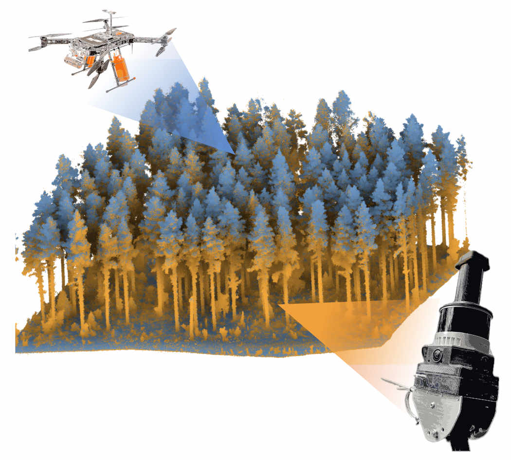
IROS 2024: Markerless Aerial-Terrestrial Co-Registration of Forest Point Cloudsusing a Deformable Pose Graph
Abstract: For biodiversity and forestry applications, end-users desire maps of forests that are fully detailed—from the forest floor to the canopy. Terrestrial laser scanning and aerial laser scanning are accurate and increasingly mature methods for scanning the forest. However, individually they are not able to estimate attributes such as tree height, trunk diameter, and canopy density due to the inherent differences in their field-of-view and mapping processes. In this work, we present a pipeline that can automatically generate a single joint terrestrial and aerial forest reconstruction. The novelty of the approach is a marker-free registration pipeline, which estimates a set of relative transformation constraints between the aerial cloud and terrestrial sub-clouds without requiring any co-registration reflective markers to be physically placed in the scene. Our method then uses these constraints in a pose graph formulation, which enables us to finely align the respective clouds while respecting spatial constraints introduced by the terrestrial SLAM scanning process. We demonstrate that our approach can produce a fine-grained and complete reconstruction of large-scale natural environments, enabling multi-platform data capture for forestry applications without requiring external infrastructure.
Publication
- “Markerless Aerial-Terrestrial Co-Registration of Forest Point Cloudsusing a Deformable Pose Graph”, Benoit Casseau, Nived Chebrolu, Matias Mattamala, Leonard Freissmuth, Maurice Fallon, IEEE/RSJ Intl. Conf. on Intelligent Robots and Systems (IROS), 2024.